I want to use this page to provide support for you in anyway that I can so if you have any ideas please let me know via the Contact Page.
In the meantime here’s a couple of tools that you might find useful when selecting your Postcode DISTRICTs.
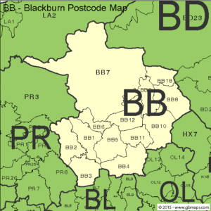
Identifying Your Postcode DISTRICTs
Need help deciding which Postcode DISTRICTs to choose? I know I did. Do you know your neighbouring Postcode DISTRICTs? I didn’t which is why I am delighted that I found GB Maps.
They produce maps with exactly what I was looking for. A simple way to visualise my surrounding Postcode DISTRICTS. For this example I have used Blackburn which has an BB postcode area and I will use BB5 – my home Postcode DISTRICT. I gave a ‘live’ example on the About Us page that detailed the 16 Postcode DISTRICTs that I would choose and you can see why I would choose them on this map (BB1 to 12 excluding BB7 and PR5, 6, 7, 25 & 26). M65 motorway, end to end.
You can also see the BL and OL postcode areas and subsequent Postcode DISTRICTs should I want to expand – if there are spaces left. The maps are free to download. Click the button below and find your Postcode AREA and that will show you the Postcode DISTRICTs around you.
How To Find Your Household Coverage
You may also want to look at the number of households that you are targeting with your choice of Postcode DISTRICTS. My 16 choices target at least 240,000 households and don’t forget that is households only. Businesses are not included in this figure. BB7, which I left out of my plan, is a big DISTRICT but not densely populated. I could add it later IF it was still available.
To find out this information I used a website called Postcode Area and you can reach them using the button below. Once there simply type a Postcode DISTRICT into the search bar – try my Postcode DISTRICT, BB5 – and the number of households will be displayed. There are 27,400 households in BB5. It’s that easy to use and now you can plan your own work area.
*Unfortunately, this only works for England and Wales and a few Scottish Postcode DISTRICTs at the moment.